
The Siliguri Corridor: The Iron Fist: How India is Turning from a Vulnerability into a Fortress
If I were to ask you to name India’s ultimate geopolitical nightmare, what would your immediate answer be?
Most people would instinctively point their fingers toward the high-altitude, snow-capped mountains of Kashmir. Others might talk about the cold deserts of Ladakh, where Indian and Chinese troops have stood eyeball-to-eyeball in recent years. Some might even guess the dense, heavily forested borders of Arunachal Pradesh.
But if you ask any seasoned military strategist or geopolitical analyst where India’s true, aching vulnerability lies, they will tell you that our greatest collective nightmare doesn’t reside in those dramatic landscapes. Instead, it is quietly tucked away in a small, narrow strip of land in West Bengal.
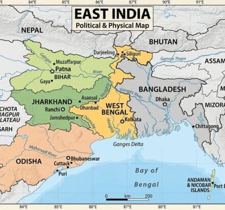
In the language of international relations and military doctrine, this place is famously—and anxiety-inducingly—known as the “Chicken’s Neck.” Geographically, it is the Siliguri Corridor.
For decades, this thin sliver of land has been the central obsession of India’s defense planning. It has been our Achilles’ heel, a natural bottleneck that a determined enemy could exploit to fracture our nation. But as you read this, a monumental shift is unfolding on the ground. Recent, breaking developments out of West Bengal are turning decades of defensive anxiety on its head.
Let’s dive deep into the geography, the history, the military tactics, and the massive political shift that is currently transforming the Siliguri Corridor from India’s greatest vulnerability into an impenetrable iron fist.
1. To Understand Geopolitics, You Must First Master Geography
There is an old adage in military strategy: “Generals study tactics, but masters study logistics and geography.” If you want to understand the geopolitics of South Asia, you must first look closely at the map of eastern India.
When you look at the Siliguri Corridor, you see a remarkably narrow strip of land. It is an international crowded house.
- To its absolute North, you have the kingdoms of Nepal and Bhutan.
- To its immediate South, the border of Bangladesh begins almost instantly.
- At its absolute narrowest point, this entire corridor measures a mere 20 to 22 kilometers in width.
Think about that for a moment. A mere 22 kilometers of territory is all that physically fastens the massive mainland of India to its eight stunning North-Eastern states (including Sikkim).
Plaintext
[ NEPAL ] [ BHUTAN ] \ / \ (Tibet / China) / ======= THE SILIGURI CORRIDOR ======= -> ONLY 20-22 KM WIDE! / (“Chicken’s Neck”) \ / \ [ BANGLADESH ] [ 8 NORTH-EAST STATES ]
This structural reality makes the corridor a classic geographic bottleneck. If an enemy power managed to sever or effectively block this 22-kilometer gap during a geopolitical crisis, the entire North-East of India—Arunachal Pradesh, Assam, Meghalaya, Mizoram, Manipur, Nagaland, Tripura, and Sikkim—would be completely cut off from the Indian mainland.
The mere thought of such a scenario is terrifying. It represents a logistical and existential catastrophe that India simply cannot afford to risk.
2. The Sole Lifeline for Eight States
It is a massive mistake to view the Siliguri Corridor as just a random piece of real estate or a transit highway. For the eight states of the North-East, this corridor is their solitary, irreplaceable lifeline.
Trade, Economy, and Civil Infrastructure
Every single developmental project, every brick of civilian infrastructure, every commercial truck, and every ounce of daily consumer goods moving from mainland India to the North-East must pass through this exact bottleneck. There is no alternative overland route. If the corridor chokes, the economy of the entire North-Eastern region grinds to a catastrophic halt within days.
Military Movements and the Two-Front War Nightmare
Now, let’s look at this through a hard-nosed military lens. Imagine a hypothetical, worst-case scenario: India finds itself thrust into a simultaneous two-front war involving both China and Pakistan.
In such a crisis, the Indian Army would need to rapidly, flawlessly mobilize hundreds of thousands of troops, heavy artillery tanks, ammunition supplies, and armored vehicles directly to the forward operational borders of Arunachal Pradesh and Sikkim.
Because the Siliguri Corridor is so narrow, the flow of men, money, and material during a wartime emergency creates an intense logistical bottleneck. The roads and railway lines running through this 22-kilometer strip have strict capacity limits. If a massive logistical traffic jam occurs here, it slows down India’s operational speed—which is exactly what an adversary wants.
If this vital line of communication is choked or broken:
- Forward-deployed jawans on the icy borders would be isolated.
- The supply of fresh rations, heavy ammunition, and medical equipment would stop.
- Sending critical reinforcements or heavy backup from mainland military bases would become a logistical impossibility.
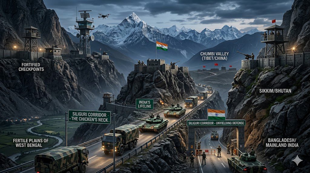
3. Enter the Dragon: The Shadow of China and the Chumbi Valley
While the corridor is bordered by Nepal, Bhutan, and Bangladesh, India’s primary security concern in this region does not stem from these three neighbors. The real, deadly threat comes from the north: China.
To understand why the Siliguri Corridor is under constant threat, we must look at a specific geographic feature known as the Chumbi Valley.
[ CHINESE TIBET ] | | <– Chumbi Valley (Points like a dagger) v [ DOKLAM ] | v ============================= SILIGURI CORRIDOR (22 KM) =============================
The Chumbi Valley is a slice of Chinese-controlled Tibetan territory that juts downward between Sikkim and Bhutan. On a map, it looks precisely like a sharp dagger pointing directly at the heart of India’s Chicken’s Neck.
Lessons from the 2017 Doklam Standoff
To fully comprehend the gravity of this situation, we only need to look back to the summer of 2017. For 73 tense days, the Indian Army and China’s People’s Liberation Army (PLA) stood eyeball-to-eyeball on the remote Doklam Plateau.
At the time, many casual observers wondered why India was adopting such an aggressive, unyielding stance over a piece of land that technically belonged to Bhutan. The answer lies entirely in the strategic geography of the Siliguri Corridor.
The Doklam Plateau is a vital vantage point situated right above the Chumbi Valley. If China managed to alter the status quo, build military infrastructure, and establish a permanent, heavy military base on Doklam, they would gain a direct, unobstructed line of sight over the entire Chicken’s Neck.
With heavy artillery positioned on those heights, Chinese forces could target and disable India’s critical national highways and railway networks in the corridor within minutes. It would give Beijing a metaphorical kill-switch over India’s connectivity to the North-East.
The Doctrine of ‘Salami Slicing’
China’s military doctrine has historically relied on a strategy known as “Salami Slicing”—encroaching upon small, incremental pieces of land over time so gradually that it rarely triggers an outright war, until one day the strategic balance has completely flipped.
For years, the PLA has attempted to edge closer to this corridor. Their ultimate goal has always been simple: position themselves so that in a flashpoint moment, they can launch a rapid strike to disconnect the North-East from India, creating chaos and forcing New Delhi into a position of weakness.
4. The 120-Acre Masterstroke: Changing the Ground Reality
For decades, India’s defense planners understood this threat perfectly. Yet, our response was frequently hampered by a domestic, bureaucratic nightmare: political friction and center-state tussles.
In democratic India, land acquisition is a slow, painfully sluggish process. Because the Siliguri Corridor falls entirely within the state of West Bengal, any major military expansion required seamless cooperation between New Delhi and Kolkata. For years, political egos, ideological differences, and administrative red tape meant that crucial land acquisitions for national security crawled at a snail’s pace.
But the ground reality of the Siliguri Corridor is undergoing a rapid transformation.
The Big Strategic Shift: The West Bengal government, under the leadership of Chief Minister Suvendu Adhikari, has executed a massive strategic move. The state government has officially initiated the process to transfer 120 acres of land within the highly sensitive Siliguri Corridor directly to the Central Government.
This is not just a standard administrative land transfer; it is a monumental development for both internal and external national security. It effectively removes the bureaucratic roadblocks that have stymied India’s eastern defense planning for a generation.
5. Connecting the Dots: What is the Center’s Game Plan?
While the Central Government has understandably not made a public blueprint available—national security matters demand a high level of confidentiality—we can easily connect the dots by analyzing modern military strategy.
An acquisition of 120 acres right in the core area of a vital bottleneck is an immense asset. It gives India’s armed forces the room they need to transition from a defensive posture to an active, forward-ready stance.
Here is how defense experts believe this 120-acre parcel will be utilized to reinforce the Siliguri Corridor:
1. Integrated Military & Logistics Hubs
Previously, if tensions flared up along the borders of Sikkim or Arunachal Pradesh, heavy machinery and reinforcements had to be mobilized from distant mainlands, fighting against the natural limits of the corridor’s transport links.
With this new acreage, the Indian Army can establish highly advanced, forward-operating logistics hubs directly inside the corridor. This means heavy machinery parking, massive troop barracks, and supply nodes will be permanently positioned at the gateway itself.
2. Undergound Ammunition Depots
To safeguard vital munitions from aerial threats or long-range artillery shelling, this land allows for the construction of fortified, underground ammunition blast-depots.
By pre-deploying and heavily guarding essential weaponry at this precise location, India ensures its troops do not have to wait days for ammunition trains to arrive from central India. If an adversary attempts a provocative move, India’s response time drops from days to mere minutes.
3. High-Tech Surveillance and Drone Warfare Units
Modern conflicts are dictated by information warfare and real-time surveillance. This consolidated land parcel offers an ideal footprint to set up advanced radar systems and 24/7 drone monitoring command centers.
From this central point, Indian security forces can maintain an eagle-eye view over everything from the Chumbi Valley to the porous borders of Bangladesh, neutralizing threats before they even reach the corridor.
Through these steps, India is effectively transforming a historical chokepoint into an Iron Fist. The very area an adversary might view as our weakest link is becoming our most formidable defensive shield.
6. Political Will 2.0: The Backbone of Geopolitics
Geopolitical strategies look excellent on paper, but they are functionally impossible to implement without internal political will. The rapid acceleration of security measures along the Siliguri Corridor is tied directly to a structural shift within West Bengal’s internal governance.
For a long time, infrastructure initiatives in Bengal faced persistent delays due to bureaucratic hurdles and political friction between the state and the center. However, the rise of a highly proactive administration in West Bengal has brought a clear alignment of priorities to the table, paving the way for definitive action on national security.
Beyond the 120-acre land transfer, a look at recent administrative policies reveals a broader focus on law, order, and border security:
- Implementation of the Bharatiya Nyaya Sanhita (BNS): The state has prioritized rolling out these updated national criminal laws with full administrative backing, signaling a clear focus on strengthening institutional law and order.
- Fast-Tracking the Bangladesh Border Fencing: For years, border porosity and illegal infiltration were major challenges that impacted both regional demographics and internal security. The current administration has significantly accelerated the long-pending border fencing work, effectively securing the wider region around the corridor.
- Zero-Tolerance Administrative Policy: Clear instructions have been issued across the state’s police administration to dismantle syndicates, eliminate political violence, and enforce the rule of law without compromise.
A nation’s external defense is only as strong as its internal stability. By prioritizing governance, streamlining land management, and implementing welfare programs like Ayushman Bharat, the state is reinforcing its administrative foundation—enabling India to face external strategic challenges from a position of domestic strength.
7. The New Era: From Defensive Defense to Active Deterrence
To summarize the true impact of these developments: this is about far more than a simple land transaction in West Bengal. It represents a fundamental evolution in India’s grand strategic outlook.
| The Old Approach (Defensive Defense) | The New Approach (Active Deterrence) |
|---|---|
| Sluggish land acquisition hampered by political friction. | Proactive, rapid land transfers for national defense needs. |
| Reliance on bringing reinforcements from distant mainland bases. | Pre-positioning troops, logistics, and ammunition at the core chokepoint. |
| Vulnerability to adversary ‘salami-slicing’ tactics. | Clear, multi-layered defense to neutralize threats within minutes. |
Securing the Siliguri Corridor sends a clear, unambiguous message to the world: India’s connection to its North-Eastern states is absolute, permanent, and non-negotiable. No external power or internal element can disrupt this bond.
By replacing long-standing bureaucratic hurdles with decisive strategic action, India is successfully turning an old geographical vulnerability into an enduring source of national strength. The Chicken’s Neck is no longer an open target—it has become a fortress.
What Are Your Thoughts?
The transformation of the Siliguri Corridor marks a major milestone in how India manages its borders and handles national security. How do you see this shift altering the strategic balance with China over the next decade? Let’s get a conversation started in the comments below!
Editor’s Pick
-
 Read more: Standardized Excavation Measurement Benchmark – IS Code Explained
Standardized Excavation Measurement Benchmark – IS Code Explained
on
-
 Read more: Bar Bending Schedule Essentials: Common Errors and Practical Insights for Civil Engineering should help your Knowledge in 2026
Bar Bending Schedule Essentials: Common Errors and Practical Insights for Civil Engineering should help your Knowledge in 2026
on
-
 Read more: Recruitment Scams and the Promise of Reform in Govt of West Bengal 2026
Recruitment Scams and the Promise of Reform in Govt of West Bengal 2026
on
-
 Read more: Pile Foundation: The Hidden Strength Beneath Every Structure Now even in 2026
Pile Foundation: The Hidden Strength Beneath Every Structure Now even in 2026
on